Tuesday, March 30, 2010

Life at Sea in 20 Knots

20 knots, for the non-sailor, is about 25 mph. That's a lot of wind. We've been 'messing about' in 20 knots of wind for the last 2 days. But wind isn't the big deal. Wind is actually a good thing. Wind makes the boat go.

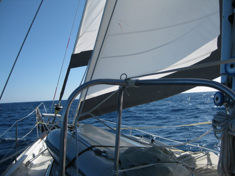
What IS the big deal are the seas. Over time, as the wind blows, the seas get bigger and bigger. Right now we have large waves--about 10 to 12 feet in height. Those are pretty big waves... almost twice as big as the average Satellite Beach wave (they are usually in the 5-6 foot range). Waves this big are really awesome.

We are 'running downwind' right now... that means going with the wind. The significance in sailing is that we are not heeled over. That's nice. But we are surfing down these big 10 foot waves, and rolling from side to side.

You cannot sit anywhere aboard, without bracing yourself to keep in place. To walk from our cabin to the main cabin, and then to the forward bathroom, you have to move from handhold to handhold (all conveniently spaced about 3 feet apart, just for this purpose). You have to time your walk with the roll of the boat.

You cannot put ANYTHING down and expect it to still be there in 5 minutes. Anything with any weight will get hurled across the cabin on the next roll. So we have to keep everything put away in cabinets or drawers (all specially designed to be self-locking, so they won't fly open in conditions like these). For a temporary spot to put things, we have a nice deep sink. But stuff slides back and forth in the sink too.

Cooking is truly a challenge. Just simple things like cutting up vegetables is an adventure. Put the knife down for a second, and it goes flying. Chop a piece of carrot off, and IT goes flying. There aren't enough hands to hold on for yourself, hold the knife, and hold on to the pieces of what you're cutting up. The stove is designed for this... it is built on a pivot to stay level when you are heeling (leaning over when sailing). Pull a couple of pins and, voila, it's level. It also has some brackets that you can attach to hold the pans in place, so THEY don't go flying.

In conditions like this, we eat in the cockpit, one-pot meals served in a bowl in our lap. It takes a lot of of inventiveness in the galley (kitchen) to come up with more than one 'delicious' one pot meal in a row. They tend to all start tasting alike after a couple in a row.

We normally drink water from a water bottle--it tends to hold its contents better than a cup when vaulted across the cockpit, and means we have one hand left to actually eat with.

Sleeping is also an adventure. The boat is pretty noisy when we're sailing in 20 knots of wind. Everything is creaking (not just the rigging, but the woodwork inside the boat). As we are going through the water, there's a lot of water pounding on the hull. And there's the sound of the wind and waves going by. The bed is moving in a pretty lively fashion, and it takes some creativity to get yourself wedged in where you can relax in that kind of movement, and sleep. We are usually braced on the downhill side with a foot or two, and spread out on the bed to stabilize things.

Yep, we are having fun out here!
-----
At 3/30/2010 2:13 AM (utc) our position was 27°12.00'S 121°54.77'W

----------
radio email processed by SailMail
for information see: http://www.sailmail.com

Monday, March 29, 2010

Enroute Easter to Pitcairn - Day 6

Well, we ended up motoring for just over 24 hours. We stopped once or twice to try sailing, but it just wasn't possible without slamming the sails (and us) around. We finally found sailable wind yesterday morning at about 11am (just as forecast).

The wind slowly built yesterday afternoon to about 15-20. At first it was not steady and drove us crazy... we'd get everything (3 sails, autopilot) all trimmed up for one windspeed, and then the wind would drop off to 8 knots, and we'd be all screwed up again, with the sails slapping and the boat rolling. When running downwind, as the wind speed changes, everything changes.

Fortunately, by last night, the wind steadied up at about 15-18 knots. We've got a triple-reefed main, staysail, and a scrap of genoa out, and are mostly doing about 6 knots. The seas are pretty big and are slinging us around some, but as long as the wind stays steady, it's not too bad.

The skies cleared last night, so we were able to enjoy a nice bright moon, and we have a pretty crystal blue day today.

We are sailing at 6 knots right toward Pitcairn (for now).

Our friends on Visions are now about 120 miles ahead of us, and they are getting beat up pretty badly. They are closer to the warm front we've been worrying about, and are seeing winds of 25-30 knots. (YUK!!) Infini is about 50 miles behind us (they don't motor as fast as we do), and have the same conditions we do.

We are ALL tired of this... if I could just say "beam me up, Scotty" I would (as long as the Enterprise wasn't under fire from alien forces).

605 miles to go to Pitcairn, and then another 300 miles after that to get to the Gambier archipelago (part of French Polynesia). There we hope to find a calm, enclosed anchorage for the first time in over a month.

This sure is a big patch of ocean down here!

We are not sure we'll be able to actually STOP at Pitcairn...but the current forecast looks like it might be possible. Pitcairn has an even worse anchoring situation than Easter does, and conditions have to be pretty near perfect to be able to stop there AND actually get off the boat and go ashore (safely). We're keeping our fingers crossed!
-----
At 3/28/2010 4:11 PM (utc) our position was 28°09.07'S 119°20.91'W

----------
radio email processed by SailMail
for information see: http://www.sailmail.com

Saturday, March 27, 2010

Enroute Easter to Pitcairn - Day 4

It seems to be always too much wind or too little. We've gone from 20 knots to 5 knots to 25 knots to 5 knots, with very short 'reasonable' periods in between.

Right now we have about 5-7 knots from the SE, and we are headed WNW (almost dead downwind). We could almost sail this if the seas were as flat as the wind. But we still have about 6-8 feet of swell coming from the SE. We can't keep any sail full. Here is my logbook entry for the last hour:

Engine off, main and genoa out, making 3 knots.
Genoa in, Code Zero out
Main down (trying to keep the Code Zero full)
Code Zero in (can't keep it full)
Main up and engine on

Each of these line items entails about 15-20 minutes of screwing around with sails.

At least it isn't hot. Air temp is 70 degrees at night and 75 degrees during the day. Yesterday we spent all day in 100% overcast but today at least we have a nice sunny day with a few puffy clouds.

At our weather conference last night (among our 3 boats), we discussed the next big weather event--a low and a cold front approaching from the west. We're now heading for supposedly north of the NE end of the cold front, to try to stay out of the 25-30 knot winds forecast further south.

We are all thinking longingly of sailing in the tradewinds, where the wind is more or less steady.

I am trying to get a GRIB file in to see what the revised weather outlook--unfortunately we are so far 'out there' that it's difficult connecting with any of the Sailmail stations at this time of day. The closest and easiest station to connect with is Chile, but it is having internet issues and quite often just doesn't pass traffic. I've given up using it, and the rest of the stations are too far away. Thank God we thought to get the Iridium phone as a backup.
-----
At 3/26/2010 6:31 PM (utc) our position was 28°46.71'S 114°58.00'W

----------
radio email processed by SailMail
for information see: http://www.sailmail.com

Thursday, March 25, 2010

What Were We Thinking?

When we were at Easter Island, desperate to get moving to the next 1100 miles further west, the weather for going west didn't look very good. Most of the wind on a direct line between Easter and Pitcairn was on our nose and/or very light.

Our friend Bill on Visions of Johanna, said, "No problemo, lets just head south, cut across a dissipating cold front, and ride the winds between the High and the Low." He has a fancy program (Expedition) that will take the GRIB file forecast and plot out a route. He has also paid a weather forecaster to give him advice on routing for this trip. (Ken at locusweather.com)

We were a little desperate while sitting there at Easter Island, with bad weather where we were and worse weather coming, and nowhere else to go. But seriously, next time I contemplate chasing wind in a Low, please kick me!!

We spent all day yesterday motorsailing SSW in very light air. The latest GRIB file showed the Low receding, and we were worrying about ever finding wind. Then, all of us a sudden (about right where it was supposed to be), we had the wind we were looking for. Beautiful ESE winds at about 10-12 knots. We turned off the engine and piled on all the sail we could muster, and were making 6 knots in the right direction under sail alone.

At our evening radio schedule at 1915 (7:15pm local), Bill, who was then about 50 miles ahead of us and further south, reported that they'd been in 20-30kt winds for hours, and to "watch out, don't come so far south". I changed course from SSW to West immediately, while Dave was still talking on the radio.

Thankfully, forewarned is forearmed, and when just 15 minute later we were hit by the first puff of 20-25kt wind, we knew what it was and rolled in the big genoa. 5 minutes later we were fully engulfed in Bill's 20-30 kt winds. As it got dark, Dave took in a 3rd reef in the mainsail. It was exciting, but with the right sailplan, not dangerous.

We sailed all night in 20-30 kts winds, with just the triple-reefed main and the staysail, making 7-8 knots! The waves were huge, and we were surfing down the face of the waves most of the night. The air temp dropped to a chilly 70 degrees and we had rain off and on during the night.

We started this trip pretty sleep-deprived--the last couple of nights at Easter were pretty sleepless. And the last 2 nights at sea were pretty challenging. We didn't take any day naps during the day yesterday, worrying about whether we'd ever find any wind or not.

Now we need to delicately feel our away along the isobars, trying to stay in wind, but not too much wind. Very far north, and the wind dies completely and/or becomes a headwind. Very far south of here and conditions get much worse.

But we are OK. We are in a sturdy boat, built to take this stuff. "Janet" (our CPT autopilot) is working her little heart out to keep us going in the right direction. No major failures to date.

BTW, we celebrated our 3rd wedding anniversary last night, with cold spaghetti in our laps. (Some anniversary cruise Dave took me on!!) We ARE both thankful to be here, and to be here with each other.
-----
At 3/25/2010 2:32 PM (utc) our position was 29°05.46'S 112°28.40'W

----------
radio email processed by SailMail
for information see: http://www.sailmail.com

Easter Island to Pitcairn Island - Day 2

We left Easter yesterday after a very rushed morning clearing out and getting the boat ready. The winds were honking along the south coast of Easter as we sailed west... 20-25 knots. It wasn't too bad until we cleared the west end of the island and got exposed to the full sea. Big waves!! We had several waves break and wash green water over the top of our dodger.

Things gradually calmed down last night--except for a few 30 knots squalls. This morning the wind went to nothing (something we expected) and we turned the engine on and started motoring SW. We are hoping to find good winds on the other side of the Low that we're motoring across (but the latest GRIB weather files show the windy area receding almost as fast as we're going).

There is a complex group of highs and lows in this area and we're trying to thread our way underneath a low and over a high, but NOT in a 'squash zone'. We are amazed at how relatively accurate the GRIB files are way out in this remote corner of the world. Thank goodness for Sailmail and Saildocs (how we get our weather files).

This could be a long trip!

It is saying a lot that I got a better night's sleep last night on passage than I did the last 3-4 nights at Easter Island.

That's what we call 'Adventure Cruising'!!
-----
At 3/24/2010 11:14 PM (utc) our position was 29°01.40'S 110°45.23'W

----------
radio email processed by SailMail
for information see: http://www.sailmail.com

Unsettled Weather Chases Us from Easter Island Prematurely

Sunday we were supposed to have rented a car to go do a self-tour at the other end of the island. But while we were waiting for the surf to subside after our dinghy disaster, I walked up and canceled the rental--the surfers and the dive shops said the surf would stay bad tomorrow too. And we saw from the GRIB files that a weather change was coming.

The next 36 hours were pretty bad as the swell built from NE, and the wind swung to the NE--a direction that isn't a good one anywhere on Easter Island.

3 of the 7 boats opted to go ahead and leave for Pitcairn/Gambiers that evening, and the Chilean Armada guys were so helpful in coming out to the boats to clear them out of Chile.

Infini Beating to Windard On the South Coast

After the 2nd really rolly awful squally night at Hanga Roa, with the wind backing more toward the north, and a huge swell building, we left at dawn for an anchorage on the south side of the island. It was Soggy Paws and Visions and Infini in a parade out of the anchorage, and then beating our way east against 20-25 kt winds.

When standing off the Hotu Iti anchorage, which we had waypoints for, I could not believe there would be any protected anchorage there. But Visions, much faster than us, had arrived ahead and assured us that it was better than Hanga Roa, at least.

The Rugged Coast and the Hotu Iti Anchorage

If you look closely in this picture, you can see 2 masts at the foot of the black cliff. Infini is on the left, rolling, and Soggy Paws is on the right. Visions is tucked further back in the cove, and is hidden by the headland.

We spent the next 2 nights rolling our guts out at Hotu Iti. It is a pretty place, but we had gusty winds from NE and an 8 foot swell rolling in around the headland, from the SE. We were often exactly sideways to the swell. Very difficult conditions.

Sitting in the anchorage, we wondered where we were going to land a dinghy. It turned out that there is a small man-made 'dinghy harbor' hidden along the shore.

The Dinghy Harbor at Hotu Iti

After we got the anchors down, checked the weather forecast, and assessed the situation, Visions decided they were going to clear out for Gambiers. Officially, you are supposed to bring your boat to Hanga Roa (where we just left, where anchoring is now untenable, and where landing a dinghy would be impossible) So they called the Armada on VHF and asked if they'd come out with their paperwork to this remote anchorage, 10 miles out of town.

Though we hadn't really had as much fun as we planned at Easter Island, faced with a forecast that showed more of the same difficult conditions for about another week, we decided to go to. Dave and Mike hitched back to town with the Armada guys, rented a car, and we spent all day running errands (filling diesel jugs, shopping, last minute internet, etc). We only took a few minutes to snap a photo of the "14 Heads", the big ahu called Ahu Tongariki.

Ahu Tongariki,
as Restored


After another rolly night, the wind was finally starting to switch around to the N and NW, the sun came out, and the swell was calming down. We had hoped to spend the morning exploring the Ranu Raku Volcano, where all the moai were carved. It is only a half hour hike from the Hotu Iti. But the Armada called us on the VHF and said more bad weather was coming, and we should leave. We had enough 'getting ready' to do that we decided not to take time to see Ranu Raku.

So yesterday, Visions left Easter Island in the morning, and Infini and Soggy Paws left just after noon. The forecast shows west winds all across the direct route from Easter to Pitcairn and the Gambiers. So we are doing a tricky 'dive south' maneuver to try to pick up winds off a high pressure area south of here. We'll see how that works out.

We are sad that we didn't get to see all major sites on the island, and didn't get to go diving. Another 2 or 3 days of settled weather would have done it, but that was not to be.

We have a total of 1400 miles to go to our end destination--the town of Rikitea on Mangareva in the Gambier Islands of French Polynesia (approx 23S 135W). We hope to make an intermediate stop at Pitcairn Island, if the weather permits.
-----
At 3/24/2010 11:14 PM (utc) our position was 29°01.40'S 110°45.23'W

Sunday, March 21, 2010

Easter Island Dinghy Disaster

Surfing In the Dinghy On a Settled Day

Today was scheduled to be a 'work day'. Sue from s/v Infini and I went grocery shopping. We walked all over town and shlepped large bags full of meat, veggies, and other necessaries back to the dinghy, while the guys were back aboard doing minor repairs.

We got in thru the surf OK by ourselves in Sue's dinghy, but but when we got back to the dinghy, wow, was the surf big. Getting in and out of the small boat harbor is an adventure on a normal day. Well, this turned out to be more of an adventure than we'd planned.

The Surf Line between Boat and Dinghy Beach on a Mild Day

What we'd been told is to idle at the dinghy beach area and watch and wait for a big "set" of waves to finish, then race out thru the surf zone in the calm that follows.

Well, what we didn't know was that at this time, there was not going to be any calm. And we were in a hurry--the guys were waiting for the dinghy to go get diesel. So we idled out into the surf zone and somehow got 'committed' to going, and there was no calm.

To make a long story short... we made it over the first wave, but then got a little further out where a REALLY BIG wave was coming. There was nowhere to go. We went straight up the wave face and then curled over backward as the wave broke. Sue and I were in the surf, along with the dinghy and all our groceries. It was an exciting time to say the least.

Both Sue and I are good swimmers, but this was really a challenge. The waves were so big, we weren't making a lot of progress toward shore, and were getting tired. We finally gave up trying to save our stuff and concentrated on saving ourselves!!

Fortunately, there were lots of surfers nearby and they soon came to our rescue. I think the locals are used to this drill. One surfer helped Sue up onto her board. She was getting really tired. A couple of guys helped me (between huge crashing waves) get the dinghy flipped back. Then they got me in the dinghy and guided me in to the beach.

Some of the guys were gathering up our floating groceries on their surfboards. And someone called the Chilean Coast Guard, and they were soon out in jetskis helping to collect stuff too.

In the end, we lost about a third of our groceries. Sue lost a handheld VHF, and her camera, which was in a nylon 'drybag', is now toast. She was able to retrieve her bag that had her money and passport in it (though it was all soaked). My camera was in a better drybag, which one of the surfers retrieved. It got a few drops of water on it, but Dave cleaned it up and it's working for now. I did lose my small change purse with 3 credit cards in it, which was just in my pocket.

The bad part was that the dinghy motor needed to be worked on ASAP, to flush the salt water out. But the guys were stuck out on the boats--the conditions were too bad for them to come in. Fortunately, the Chilean Coast Guard mechanic volunteered to take the outboard back to their shop and work on it immediately--gratis. What a very nice gesture.

The Dinghy Beach on a Better Day

Sue and I spent all afternoon on the shore trying to dry our stuff out, and watching the surf, wondering how we were going to get back aboard. Finally, another cruiser with a small dinghy hired a fisherman to load their dinghy on his big outboard-powered launcha, and take them out. So when he came back, we negotiated a ride too. It was an exciting trip thru the surf--still huge waves--with our dinghy in the middle of the boat, and Sue and I crouched in the fish guts, trying to hang on and keep from getting crushed by our dinghy! It was Well worth the $20 we paid him.

Mike and Dave, fortunately, knew nothing of our disaster until it was all over. They were going to come in and 'rescue' us, but we convinced them that the surf was too bad and we didn't need another disaster. They did notice a bunch of bananas float by, so they got in our (Soggy Paws') dinghy and ran around gathering up whatever they could. They retrieved quite a few useful things too.

Unfortunately, no one we know took pictures of our adventure. In these pictures here, the surf is very modest.

Saturday, March 20, 2010

Exploring Easter Island

Soggy Paws at Anchor off Hanga Roas

We did have 2 nice days at the Hanga Roa anchorage, where the weather was settled enough that we enjoyed ourselves.

We took an afternoon amble around the "moai" (big stone heads) near Hanga Roa, the main town, and we went to the Museum.

We liked this sign telling tourists not to climb on the artifacts.

Don't Walk on the Moai!

What is so amazing is that the statues are HUGE. See the picture below with Dave and I in the foreground. The big mystery at Easter Island is how the islanders transported these big statues close to 10 miles over rough terrain, set them upright, and then put the 'hat' on top.

We Pose for Perspective in Front of a Solitary Statue

When the first Europeans arrived at Easter Island in the 1600's, most of the statues were still in place. They ring the coastline and can be easily seen from the sea. But by the time later explorers arrived, many of the statues had been thrown down, presumably by inter-trival warfare. By the end of the 1700's, there were no statues left standing.

The Head of a Statue in Front of a Destroyed Ahu

The statues that are standing today have been restored by various efforts over the last 100 years.

The Birdman Islands

The second day we took a half day tour of the north end of the island, where the 'birdman cult' hung out. This is the Easter Island 'religion' that succeeded the moai-builders, and is centered around an extinct volcano crater and a couple of small islands offshore. To decide who next year's ruler was, a representative from each party would swim out to the island and wait for the seabird nesting to begin. The group who's representative was the first to bring back (swimming across a half mile of open ocean, and scaling a very tall cliff) the first bird egg, got to rule the island for the next year. The actual 'birdman' also got the pretty girl, we understand.

Looking at Cave Art

We also took a walk around town and scoped out things like dive shops, laundry, groceries, internet, and souvenier stands. Dave bought a bunch of Easter Island stamps at the Post Office, and we got an Easter Island stamp in our passports.

Tomorrow we plan to get some chores done... groceries and laundry for Sue and I, and boat repairs and diesel for the guys. Then Sunday we have a car reserved to go see the rest of the island.

Thursday, March 18, 2010

Cleared in to Easter Island

Chilean Officials

When we arrived at Hanga Roa (the town on Easter Island), we called 'Pascua Radio' and reported in. They told us to expect officials to come out to the boat at 3pm.

It was a nice group, very courteous and very professional. The agricultural inspector confiscated my remaining onions and garlic from the hanging basket in the galley. On another boat they confiscated their Panamanian honey. Chile is very protective of their agriculture, and each of these items is a possible threat to their industry.

Once cleared in, we went ashore to meet up with Mike and Sue from s/v Infini. They gave us the 'nickel tour' of town, and we went promptly to the internet cafe. I only had 250 emails waiting for me!!

We celebrated our arrival at Easter Island on Infini with a bottle of champagne.


It turned into an all-anchorage party when the boat next door rowed by.

Andy and Reanna sailed in their smallish sailboat from Chile via Juan Fernandez (an island partway between mainland Chile and Easter Island). They were there when the tsunami hit, and barely got away with their boat intact. It happened at night and apparently the wave went very high into the town. They said there were people, houses, and cows floating by screaming in the dark. They picked up everyone they could, and then donated their dinghy and small outboard motor so the people could get back to their island. Andy did not want to take his boat in closer for fear of getting caught in the next wave. Wow, what a story!

We are happy that our Galapagos tsunami story is much less exciting.

Tuesday, March 16, 2010

Arrival at Easter - 13 days, 18 hours, 1891 miles

Visions of Johanna at anchor off Anakena, Moai in the background

Well, we finally made it to Easter Island, almost 3 years after sitting in the Yacht Club bar discussing the possibilities. Though it was a long and sometimes bumpy trip, it was much easier and more do-able than I'd feared.

We made an average speed of 5.73 knots, and and prior to deciding to 'motor in' in the light air last night, had only used 16 hours on the engine, including leaving port, charging batteries on a couple of grey days, and making water. Total engine hours for the trip, anchor to anchor was 23. But all of it was low-RPM motoring, so we probably only burned about 12 gallons of diesel.

We dropped anchor at Anakena Cove last night at 0230 local time. Visions of Johanna was gracious enough to wake up in the middle of the night and help guide us in to a safe anchoring spot. I thought it was a little hairy, but Dave wasn't worried at all. It's an open bay, so it really wasn't that hard.

Now that the sun has risen, we can see the moai (carved stone heads) on the beach. We are in 35-40 feet of water, but it is crystal clear and we can see the bottom easily.

Off to breakfast at Visions of Johanna!
-----
At 3/16/2010 2:01 PM (utc) our position was 27°04.16'S 109°19.47'W

----------
radio email processed by SailMail
for information see: http://www.sailmail.com

Land Ho! Easter Island!!

Our Last Sunset of the Easter Island Trip

We are currently 32 miles out from Easter Island. We could just see the tip of the island at about 50 miles out.

Today was a very nice day--moderate winds and seas, sunshine, and just smooth sailing. We tried to hold off the 'horse heading for the barn syndrome' as long as we could, but finally caught it in the late afternoon, as we were drifting along at 4 knots in only 8 knots of wind. So as soon as we got through with dinner (seared tuna and coleslaw), we cranked up Mr. Perkins, to get us in these last few miles a little quicker.

After much discussing about how wise it was to go in and anchor after dark, we have decided to make for Anakena Cove, on the north coast. Our friends on Visions of Johanna anchored there this afternoon. They gave us a waypoint, scouted an anchoring spot for us, and promised to get up at 1 am to turn their lights on and help guide us in. There is almost no wind and no seas, so it should be a pretty easy anchoring exercise.

We will get a few hours of sleep, have a nice breakfast on Visions, and then head for Hanga Roa, 10 miles away, to check in. This will let us see the coast (and the famous 'moai' along the coast) during the daylight.

The sunset tonight was spectactular. The air here in the higher latitudes is much clearer than along the equator, where we've been for the last 2 years. We took yet another sunset picture for our collection.
-----
At 3/16/2010 2:05 AM (utc) our position was 26°34.96'S 109°07.94'W

Monday, March 15, 2010

Enroute to Easter Island - Day 13

We had a good day today--the winds have moderated to just plain good sailing weather.

Last night, the skies were mostly clear, with billions and billions of stars. Today we had a nice blue sky, puffy white fair weather cumulus clouds. We had our best day ever, logging 150 miles noon to noon, an average of 6.25 knots over 24 hours. We have had hardly any squalls in the last 24 hours.

Our friends on Infini, who left about a day ahead of us, just put their anchor down at the Hanga Roa (main) anchorage at Easter Island. We are looking forward to finally catching up to them tomorrow evening!

Only 155 miles to go!!!
-----
At 3/15/2010 1:40 AM (utc) our position was 24°44.38'S 108°04.28'W

----------
radio email processed by SailMail
for information see: http://www.sailmail.com

Sunday, March 14, 2010

Our Daily Routine at Sea

After 12 days at sea, we have gotten into a pretty comfortable routine aboard.

0500 - 0900 Dave on Watch
0735 Dave wakes Sherry for 0745 Radio Schedule
0745 Radio Sked with Infini
0830 Sherry on the Computer / Radio getting weather, etc
0900 - 1200 Sherry on Watch
Dave takes a 2 hr nap
1200 - 1600 Dave on Watch
Sherry takes a 2 hr nap, plans dinner
Dave attends to maintenance issues
1600 - 1930 Both up and about
Showers
Sherry cooks dinner
1700 Radio Sked with Infini
1800 Dinner
1915 Radio Sked with Visions
1930 - 2300 Sherry on Watch
Sherry gets updated weather info
Sherry checks in with Pacific Seafarer's Net
2300 - 0200 Dave on Watch
0200 - 0500 Sherry on Watch

We chose a 3 hour nighttime watch schedule, over a 4 hour one, because it gives each of us 2 3-hour blocks of off-watch time to sleep. With a 4 hour schedule, one of us would get 2 off-watch period and the other only 1.

Dave Chats with Other Boats On Passage

We seem to be getting adequate sleep, with the 2 blocks of sleep time during the night, catnaps during our watches, and a 2 hour nap during the day.

We've ended up with 4 different times on the radio during the day. That may seem a lot, but when it's you're only contact with other human beings, it's a social thing, as well as a safety thing (exchanging positions, weather information, etc).

We are now 310 miles away from Easter Island. At our overall average speed, we'll get there about 2am on the 16th. But we are expecting the wind to gradually die off over the next couple of days, and so expect landfall around dawn on the 16th.

Our friends on Infini are still a little over a day ahead of us. And Visions of Johanna is still at Easter Island (and getting tied of the rolly anchorage).
-----
At 3/13/2010 6:17 PM (utc) our position was 21°56.16'S 106°20.83'W

Saturday, March 13, 2010

Enroute to Easter Island - Day 11

Are we there yet? Of course, we've been saying that since about the 2nd day.

Last night wasn't bad and today was OK. We had a lot of squalls today... passing rain showers that take the wind to about 20-25 knots and then the wind drops off to 5 knots. We can handle the 20-25 knot part (just a lot of cranking to furl the genoa in). But the seas are still so big that when the wind drops to 5 knots, there's nothing to keep us from rolling. So we ran the engine for about 2 hours today during the worst of the lulls.

We had a nice rain shower about an hour ago that was hard enough to wash some of the salt off the decks and windshields.

We're getting closer... 440 miles to go. At our current average speed of 5.7 knots, that will put us in at about midnight on Monday the 15th. We are anticipating some lighter winds the last day or so, so we'll probably aim to get in early on Tuesday the 16th.
-----
At 3/13/2010 1:52 AM (utc) our position was 20°36.49'S 105°31.14'W

----------
radio email processed by SailMail
for information see: http://www.sailmail.com

Friday, March 12, 2010

Enroute to Easter Island - Day 10

Last night sucked. High winds, big seas. We were tossed around all night and neither of us got much sleep.

However, today has been nice, sunny with about 12-15 knots of wind. Good sailing. We both took long naps to catch up on our sleep.


Conditions finally moderated enough that Dave braved going out on the swim platform at the back of the boat to hook up 'Henry', our Monitor wind vane. For you non-sailors, this is a device that uses mechanical means to steer the boat automatically, relative to the wind. We have been carrying this expensive, pretty, stainless steel device around on the stern of Soggy Paws since 2007, and it (so far) has gotten about 1 hour of use. Normally, we use 'Janet' our electronic autopilot.

Janet has been doing a GREAT job of keeping us on course over all these miles. But on long trips like these, we should be using the Wind Vane.


It's a little bit of voodoo magic to get it set up and working right. Dave bought ours second-hand, and it wasn't put together right. So the first couple of times we tried to use it, it didn't do the job. Dave took it apart and re-assembled it correctly, and we've finally gotten around to setting it up and using it. We tried once on the way to the Galapagos, but the wind was too light for it to be effective.


Henry has been steering now flawlessly for the past 3 hours. Henry's biggest benefit is that he runs without electricity, saving us about 24 amp-hours a day. And he doesn't eat much :) Henry is named after our friend Henry Mikelait, who is another world traveler. We are happy to have Henry guiding us around the world.

600 miles to go! About 4-5 days. We know the wind is forecast to get pretty light as we approach Easter, so we expect to slow down some the last day.

One of the other boats we've been talking to on the radio--s/v Aliisa--who left from Lima, Peru for Easter Island, said he was passed by a big cruise ship, the Oceanic, who's AIS signal said its next port was Easter Island on March 15. There goes the neighborhood! We hope it has come and gone before we get there!
-----
At 3/11/2010 10:44 PM (utc) our position was 18°20.33'S 104°03.34'W

Thursday, March 11, 2010

Enroute to Easter Island - Day 9

We covered another 140 miles in the last 24 hours. 725 miles to go.

The wind has been blowing 'briskly' all day, about 15-20 knots. But the direction is now almost on our beam (this is better than before). We are no longer beating to windward, but now just trying to keep from rolling our guts out. We have learned that too little sail is as bad (or worse) than too much sail on this point of sail. Too little sail and we roll. Too much sail and we go so fast we get scared :p We like to to keep our speed between 6 and 7 knots.

With the wind up, the seas have gotten bigger. Janet, our autopilot has been working hard to keep us on track. With the big waves slewing us around, she has to work extra hard. I hope she keeps it up!

But it was a nice sunny day all day.

Still have seen no other ships, or other signs of life. But I did see one bird today.
-----
At 3/11/2010 1:14 AM (utc) our position was 16°38.57'S 102°41.77'W

----------
radio email processed by SailMail
for information see: http://www.sailmail.com

Wednesday, March 10, 2010

Enroute to Easter Island - Day 8

Today was a pretty good day. We had some fun dealing with too little wind and then too much wind back and forth over several hours. I spent a lot of time cranking the genoa in and out today. The wind got so light (and the sea was so sloppy) that we ran the engine for an hour twice today.

We saw rain clouds going across our bow several times today, and tried vainly to catch them--we could REALLY use a fresh water rinse at this point. (Even our salt crystals have salt crystals!).

But a few hours ago all that cleared away and the wind settled down at 12-13 knots, and the sun came out, and we've been having a pretty good sail. We anticipate another nice sunset, and hopefully an uneventful night.

The forecast (GRIB files) shows that we should expect some fairly strong winds for about 24 hours, starting late tonight or early tomorrow. We are not looking forward to that! But after that, the winds look nice for sailing right on in to Easter Island.

The trade winds peter out at about 20°-25° South latitude, and Easter Island is at 27°S. So we have a couple of hundred miles to cover in the 'variables'. Our friends on Visions ended up in this area with no wind for 24 hours, and then having to motor the last 100 miles into light headwinds. We are hoping our forecast holds and we'll be able to sail right on in.

We still haven't seen hardly any life out here... only one freighter, a few birds, and no whales or dolphins. We do see lots of flying fish, and quite a few have ended up on deck in the night--I almost got hit in the head by one one night (our dodger deflected it). "We're a long way from Kansas, Toto."
-----
At 3/10/2010 12:42 AM (utc) our position was 14°31.21'S 101°23.31'W

----------
radio email processed by SailMail
for information see: http://www.sailmail.com

We Passed the Halfway Mark!!

At 0630 local time this morning, we reached 945 miles to go. We are finally half way to Easter Island.

We had a pretty good night. The wind was up and down, but within manageable ranges, and the seas were not too bad. The wind direction has eased to just barely forward of the beam, which is much better than close hauled!

The stars last night were just awesome!! It was brilliantly clear until about midnight, and we could see everything.

It has started to get quite a bit cooler here. This morning's air temp is 73 degrees F, and the water temp is down to 74.5 (they were both 80 in the Galapagos). It would be delightful if we didn't also have 20 knots of wind blowing across the deck. I've had to put long pants on and a jacket for my night watches.

We are now talking regularly to 5 or 6 boats on passage... one boat is Windy Too, 3 guys from Newfoundland, enroute from Galapagos to the Marquesas. We met them at Puerto Lucia Yacht Club in August. Another boat is Aliisa, they are a 32 footer, completing a 6 year circumnavigation in Australia. They are enroute from Lima, Peru to Easter Island. And of course, our friends on Infini, about 200 miles ahead of us, and Visions of Johanna, at Easter already.

We can still talk to some of the boats with better antennas 1000 miles away in the Galapagos, but the bulk of the Panama Pacific Net, where we have been participants and a Net Controller for the last year, is fading into the ether.

It's still early for the bulk of the boats making the Galapagos to Marquesas run. Though the World ARC boats were supposed to leave a couple of days ago. I think most people target arriving 1 Apr or later, because it's still officially typhoon season in French Poly until Mar 30. Most of our friends from Ecuador and Panama are either enroute to the Galapagos, or in the Galapagos still touring the Galapagos and getting ready to leave soon for the Marquesas.
-----
At 3/9/2010 3:00 PM (utc) our position was 13°45.18'S 100°56.44'W

----------
radio email processed by SailMail
for information see: http://www.sailmail.com

Tuesday, March 9, 2010

Enroute to Easter Island - Day 7

Last night we had a terrible night. Just about sunset, the wind came up really strong--eventually reaching 20-25 knots. And with the wind came the seas--we had big steep seas on our beam again, and were rolling like crazy, as well as banging into a pretty good wave train coming off our port bow. We tried everything to make it more comfortable--heading changes and sail reduction. We finally gave up and rolled the genoa all the way in and basically rolled and banged all night. Neither one of us got much sleep.


But this morning, the wind was down and we got a nice light rain to help wash the salt off the boat. For the first 2-3 hours, the seas were really confused... the washing machine again. But with the overcast, we needed to charge the batteries anyway, so we motored for a couple of hours. By late morning, the sun was out, the wind was steady, the seas were fine, and we were having a great sail. This continued all day, and was capped off by a beautiful sunset.

Now, about 8pm, the wind is still steady and the seas not bad. Hope this continues all night!!

We have 'only' 1006 nautical miles to go! Tomorrow morning we should reach our halfway point of 945 miles. Current ETA Easter Island is March 16. The forecast looks pretty good for the next week all the way into Easter Island.
-----
At 3/9/2010 1:49 AM (utc) our position was 12°39.91'S 100°13.60'W

Monday, March 8, 2010

Enroute to Easter Island - Day 6

We have 750 miles behind us and 1140 miles to go. ETA Easter Island sometime Mar 15 or 16.

Today has been a pretty fast day, with good winds all day, and they are starting to swing a little more east. So we've been making 6.5 knots all day with a double reefed main, staysail, and only about a third of the genoa out. The wind has been up and down between 12 and 18 knots all day.

Just before dark, the wind piped up to 20+ knots (in gusts). We now have the genoa reefed in to 'scrap' size again and we are still going 6.5-7knots. It feels like we're rocketing along. The relative wind is about 70 degrees off our port bow, so we've been able to ease the sheets a little.

Infini, about 165 miles ahead of us, said they'd been through some very windy conditions today, and it had just started to ease for them. We are hoping ours will die down through the night (it is supposed to).

We saw a ship today. They weren't transmitting on the AIS, so Dave called them the old way "Ship at 9 degrees 44 minutes south..." The ship finally answered after several calls. They are enroute from Long Beach California to the Straits of Magellan, with cargo for Brazil. When I drew a great circle line on the chart (using the charting program), it bisected our course right about where we saw the ship. I put a mark on our electronic chart to pass on to others making this passage to be especially alert in this area.

I baked oatmeal cookies today when the wind moderated a little. Something for the long night watches. I studied some more French. I spent a lot of time adjusting sails as the wind went up and down... trying to keep us moving as fast as possible but as comfortably as possible. Dave fixed a few minor things around the boat and read up on Charlie's Charts of French Polynesia (the best French Poly guidebook we have).
-----
At 3/8/2010 2:09 AM (utc) our position was 10°43.45'S 099°09.45'W

----------
radio email processed by SailMail
for information see: http://www.sailmail.com

Sunday, March 7, 2010

Enroute to Easter Island - Day 5

Today was much better. We are finally out of 'the box'!! (Yay)


The wind started moderating during the night last night. Leery of being caught with too much sail up during the night, we were slow to add more genoa, and so had our slowest noon-to-noon day yet--only 121 miles (NM). That is only an average of 5 knots over 24 hours. That's pretty slow for us. Our average speed overall as of noon was 5.6 knots.

But once dawn came, we pulled out more sail, and have been doing between 5.5 and 6.5 knots all day. The wind has stayed pretty steady at around 15 knots all day. We have only done one cycle of 'the wind has died, pull out more sail, the wind is back, reef it back in'. We have a HUGE genoa... at 120%, it is almost double the size of the 95% yankee that the CSY's originally came with. With 15-20 knots of wind, trying to trim the sail properly (and roller reef it in and out) is REALLY hard. I'm getting my muscles back--I will look like a linebacker by fall!!


The weather has been beautiful--even when the wind was blowing too hard. Sunny trade-wind conditions. The temps have dropped from about 80 in the Galapagos to 76 right now (just after sunset). Now that the wind has moderated a little, we are really enjoying the sail.

With the ride getting more comfortable, we've actually been doing something other than just hanging on. This morning I spent several hours working on my French lessons. Dave has no French, and no desire to learn. So I guess I'm "it" in French Polynesia. Fortunately, I had French in high school and college, and used my French last time around the Caribbean, as well as a little bit in Europe this fall. I still need to do some heavy 'brushing up', but at least I've got a leg up.

We also spent some time today with the guidebooks, trying to map out our short term plans for French Polynesia, and our longer term plans for what route we plan to take to Hawaii, and where exactly we want to go for 2011. (Watch our 'Cruising Plans' page on our website for updates, once we figure it out).

Our friends on Visions of Johanna arrived at Easter Island sometime today. And Infini continues to increase their lead on us--they are now 160 miles ahead of us. (Guess we should stop calling their Westsail 42 a 'WetSnail', huh?) You can see their blog at svinfini.blogspot.com. Another boat we know has just left Lima, Peru for Easter Island. They have about the same distance we do, but have a better wind angle.

We've been keeping in touch with everyone via a twice a day schedule on the SSB radio.

We are about 1/3 the way there... only 1285 miles to go!! (Current ETA Mar 15 or 16)
-----
At 3/7/2010 12:56 AM (utc) our position was 08°39.83'S 097°43.61'W

Saturday, March 6, 2010

Enroute to Easter Island - Day 4

We got out of the washing machine yesterday evening. We think it was an area of counter-current, making the seas steep and confused. All of a sudden, without any change in the wind, things smoothed out a little.

So far we have seen one fishing boat--our first night out of the Galapagos, 2 seagulls, and a lot of flying fish. No other boats, no marine mammals. It's a big empty ocean out here.

Today our focus has been to keep the boat moving at a reasonable pace, and stay dry. We want to sail at around 5.5-6 knots, but it's a struggle. The wind has been up and down all day. We get everything trimmed up just right and we're humming along at 5.8 knots, and then the wind comes up a few knots, and we start tearing along at 6.5. Faster is usually better, but in this case, it means we bash harder into the waves.

The waves, though not crazy like yesterday, are still big and still pretty much on our beam. Every now and then one breaks over us, and water washes down the deck and over everything. Occasinally when the wind comes up, we heel so far over that we bury the lee rail in the water. We have our cockpit enclosure to thank for staying mostly dry. But we've got so much foamy water on the lee rail that we have a salty mist in the cockpit, and everything is coated in salt.

We have kept 2 reefs in the main, and the staysail up, and use the roller furling genoa to slow us down or speed us up. Most of the day it has been blowing close to 20 knots, so we've varied between a 'scrap' and a 'bedsheet'. Right now our genny is only out about 8-10 feet. It isn't shaped very well when we've got it rolled in so much, but we don't care.

The forecast for the next few days is pretty much the same. The GRIB files say the wind should drop off a few knots from today's 20 knots, but not change direction much. So we'll be hard on the wind for a few more days.

With only Dave and I aboard, we are doing 3 hour watches through the night. This gives us each about 5-6 hours of night-time off-watch sleep, and we supplement that with a nap during the day, and cat naps during our watches. On Soggy Paws, we are permitted 15-minutes at a time while on watch, to cat-nap, read, or whatever. We use a kitchen timer loud enough to wake us up. After a couple of days of night watches, you get pretty efficient at sleeping in 15 minute segments, poking your head up to check on things, and then going back to sleep again. Or read... or work on the computer.
-----
At 3/6/2010 2:07 AM (utc) our position was 07°05.05'S 096°27.39'W

----------
radio email processed by SailMail
for information see: http://www.sailmail.com

All is Well

Just a quickie... we are fine, sailing 5.5 knots 215 degrees
-----
At 3/6/2010 1:30 AM (utc) our position was 07°02.47'S 096°25.29'W

----------
radio email processed by SailMail
for information see: http://www.sailmail.com

Friday, March 5, 2010

Sailing South in A Washing Machine

Galapagos to Easter Island - Day 3 - 1568 Miles (about 11 days) to Go

We are in, or almost in, Jimmy Cornell's dreaded 'box'. This is an area that Jimmy Cornell, in World Cruising Routes, says that many sailors have reported bad weather and uncomfortable conditions. In the edition of his book that we have, the 'box' is 3°S-8°S, 90°W-95°W. However, in the latest edition of World Cruising Routes, the 'box' has been repositioned to 3°S-8°S and 95°-105°W.

We Are Grateful for Our Cockpit Enclosure!

We are currently at almost exactly 5°S 95°W. After a reasonable night last night, early this morning we sailed out of a nice moonlit sky into a 100% overcast, and the seas have just gotten awful. Not big so much as confused and steep. The wind is only a little higher--and pretty much the same direction--as we've had for the past two days, but the seas are something else. It's like being in a washing machine.

We have one wave train coming directly from the side--about an 8' swell with a 4-5 second period... tall steep seas. We have another wave train, coming right on our nose--4' and not so steep. The wind is about 15-18 kts, and we are down to a double-reefed main and just the staysail. We took a second reef in the mainsail yesterday evening, after our friends ahead of us reported 20-25 kts. It never got that high during the night for us, but we were still glad we'd reefed down.

About mid morning, we rolled in the scrap of genoa that we'd left out all night, mainly because the heel from the sails, combined with the steep waves coming from the side, were really rolling us around.

So we spent a few hours wallowing along pleasantly, 20° off our desired course, only making about 5 knots. However, with the 100% overcast, we needed to run the engine to charge the batteries anyway, so we cranked up Mr. Perkins at 1pm and have been motorsailing for the last 2 hours. With the engine on, we've been able to turn up just a little, so we're now going along our desired course (about 211°), and going slightly into the big steep swell, so we're not rolling so much. As long as we don't get going too fast, it's not too uncomfortable. We are hoping to just get ourselves further south as soon as possible.

We think that around 8°S, we'll be almost out of the 'box' and start seeing the wind go further east, which should let us ease our sheets a little. Unfortunately, we have a day or two before we reach that point. :P

In contrast, our friends on Visions of Johanna (vofj.blogspot.com) have reached an area of calm just north of Easter. They expect to have to motor pretty much all day today and tomorrow and arrive at Easter Island Saturday morning.

We are getting 10 day forecast GRIB files, covering the area down to 40°S and out to 160°W, and don't see any terrible weather brewing up between us and Easter Island. (Though anyone who trusts a forecast more than 2-3 days out, especially on this uninhabited patch of ocean, is foolish). But we're keeping our fingers crossed.

Our noon-to-noon run ending at noon today was 138 miles, averaging 5.75 knots. At that speed, we have 11.36 days to go. So we'll probably make Easter sometime 15-17 March. If the wind veers more East, we should pick up speed and may shorten that by a day or so.
-----
At 3/4/2010 9:29 PM (utc) our position was 05°00.15'S 094°47.43'W

----------
radio email processed by SailMail
for information see: http://www.sailmail.com

Thursday, March 4, 2010

Enroute to Easter Island - Day 2

We had an uneventful day... the wind was up and down between 10-15 kts at about 145 degrees. Mostly nice sunny skies.

We have a reef in the main and the genoa rolled in a little. We've been averaging about 6 knots, not quite tracking down 212 degrees as we should be, but averaging a COG of about 225 degrees. The wind should swing more east as we get further south, and we expect to be able to curve right on into Easter Island sometime around the 15th of March.

No fish to report... since we are hard on the wind, we are heeled pretty good (leaning over, for you landlubbers), and have some pretty big seas, and it's a little challenging doing anything but sitting in the cockpit reading. Our freezer is stuffed so full, we wouldn't have any place to put any fish anyway.

We are chagrined to find out that our friends on Infini are going a little faster than us, so they are now just over 113 miles ahead of us. And Visions of Johanna are 2 days from Easter Island. We are still doing twice a day radio contacts with them.

Anyway, we are fine. 1677 miles to go.
-----
At 3/4/2010 1:37 AM (utc) our position was 03°32.81'S 093°34.31'W

----------
radio email processed by SailMail
for information see: http://www.sailmail.com

Wednesday, March 3, 2010

Enroute to Easter Island - Day 1

We are finally on our way, the leg we've been talking about and worrying about for years... months... days. 1900 miles, 13 days, hard on the wind for half the trip.

I can remember sitting in the Melbourne Yacht Club bar on a Friday evening in late 2006, talking about 'going to Easter Island'. It seemed like a far-off possibility. Now we are enroute! How exciting!

We didn't leave yesterday as planned, because we were still doing 'preparation' at 3:30 pm, and still had an hour or two's worth of stuff to do. The sea breeze was also blowing pretty briskly. Dave insisted that we have an early dinner, get a good night's sleep, and get going in the morning calm. Though I really wanted to get going RIGHT NOW, I couldn't argue too much with his logic.

Our friends on Infini had pulled out of the harbor at noon, though, thinking we were nearly ready to leave as well. So they were 102 miles ahead of us this morning at 8am. I think we are slightly faster than they are (a Westsail 42), so we should slowly catch up with them.

We motorsailed out of the harbor at 7:45 am, and turned the engine off as soon as we got clear of Isabela, around 10:30am. We hope to make the rest of the trip strictly under sail.

Right now, at 1330 local time, we are sailing close hauled at about 6.5 knots, making good a course between 225 and 235 degrees. The direct course to Easter is more like 212, but as we get further south, the wind will go more East, and we should be able to make Easter with no problem.

This old CSY was built for this kind of sailing, and is doing beautifully. The ride isn't that uncomfortable and the weather is just fantastic--sunny with a fairly steady wind at 10-15 knots.
-----
At 3/2/2010 9:26 PM (utc) our position was 01°29.67'S 091°34.31'W

----------
radio email processed by SailMail
for information see: http://www.sailmail.com

Tuesday, March 2, 2010

Underway For Easter!!

Finally got underway this morning at 0730 Galapagos time... 1890 miles to go!

----------
radio email processed by SailMail
for information see: http://www.sailmail.com

Monday, March 1, 2010

Planning to Leave for Easter Tomorrow

The Pacific Ocean is still sloshing back and forth a little--we are still seeing weird currents in the anchorage. But all reports from all our friends in the Pacific indicate that fortunately--this time--it was a relative non-event.

We are lucky, and we are very thankful.

We had a great evening last night with our friends on Beaujolais, another CSY who arrived in the anchorage at the same time as the tsunami. We warned them not to come in, and they hung out outside, hoping to warn us of anything 'big' before it happened. After an hour when things settled down, they anchored right behind us, hoping for a little help from Dave on their refrigeration.

While Sue from Infini and Janice from Beaujolais and I went to town for some internet and provisions, the guys worked on Beaujolais to diagnose the problem. It turned out that they have a 'broken rod end cap' (or something like that) in their Tecumseh compressor. They need a new one shipped from Ft. Lauderdale--and they need a good refer mechanic to clean their system of all the metal bits. We think we've got them lined up with a good guy in Santa Cruz. We'll leave them our cell phone sim card as well--they'll be here awhile waiting for parts.

In the afternoon, our agent, Bolivar, showed up to say hello. We weren't sure why he flew over from San Cristobal, but it turned out he had some business with the sale of a fishing boat here, and was also trying to straighten out some port captain problems (more in another post about that). But he did stop by with a huge hunk of yellowfin tuna for each boat. So we pigged out on sushi last night.

All accounts seem to indicate that Easter, Pitcairn, and French Polynesia are OK. The weather here looks good for going (though, in a 15 day passage, who knows what the REST of the trip weather will look like!!). So we are headed out tomorrow...1,900 miles. We expect to make approximately 150 miles per day. We'll be off the internet except for our sailmail email. We WILL be posting daily updates here, and you can track our progress here: http://shiptrak.org/?callsign=KN4TH&filter=30

For those of you looking for Easter Island on a map, here's a lat/long: 27°03 S 109°25 W

----------
radio email processed by SailMail
for information see: http://www.sailmail.com